
Kargil situated at 8,780ft to 18,000ft, located in the northernmost region of India, is not only known for its breathtaking landscapes but also for its pivotal role in India’s defense strategy and geopolitics. The strategic significance has been underscored by historical events, particularly the 1999 Kargil Conflict. Understanding the historical context is crucial to appreciating its importance in India’s national security.
The Kargil Conflict
The Kargil Conflict, fought between May and July 1999, was a significant military confrontation between India and Pakistan.  It began when Pakistani military forces infiltrated positions in the Kargil district, taking control of key mountain peaks that overlooked vital routes, including the National Highway 1 from Srinagar to Leh. This highway is a lifeline for the Ladakh region, and any attempt to dominate it threatened to isolate Ladakh from Kashmir. Additionally, it provided a comprehensive view of the 56 Brigade headquarters, enabling the relay of crucial information to Pakistani forces across the border.
Strategic Objectives of the Infiltration
The infiltration aimed to achieve several strategic objectives:
- Domination of Heights: Occupying the commanding heights overlooking the Srinagar-Kargil-Leh highway would enable Pakistan to effectively control this vital supply route.
- Cutting Off Communications: By establishing a firm base in Kargil, the intention was to sever communication lines to the Ladakh sector, thereby undermining ongoing operations in Siachen.
- Infiltration into Kashmir: The captured positions were also intended to facilitate the infiltration of militants and mercenaries into the Kashmir Valley.
The operation was dubbed ‘Operation Badr,’ with the primary goal of altering the Line of Control (LoC) to deny India access to critical routes.
The Terrain and Military Dynamics
Kargil’s rugged terrain presents unique challenges for military operations. In mountainous warfare, forces occupying elevated terrain hold a significant tactical advantage due to enhanced visibility and improved defensive positioning. Conventional military wisdom suggests a troop ratio of 3:1 for successful attacks in open plains, but in mountainous regions, this can escalate to as high as 9:1. This discrepancy in troop ratios proved critical during the conflict, as the Indian Army faced the dual challenge of rapid mobilization and the need for acclimatization to high-altitude conditions—typically requiring at least six days for effective adaptation. The situation was further complicated by the enemy’s occupation of key high-ground positions, which provided them with significant tactical advantages. Despite these formidable challenges, the Indian Army demonstrated exceptional operational effectiveness and resilience.
Key Battle Sites
Several critical points were pivotal during the conflict:
Tiger Hill: At 16,500 feet, this peak was strategically vital. Control of Tiger Hill not only provides India with an advantageous observation point but also enables counterattacks against Pakistani positions.
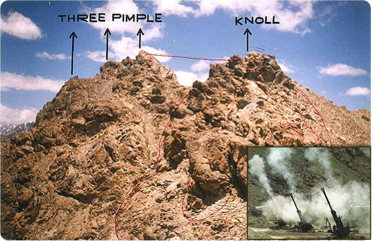
Point 4700 and Three Pimples: This complex included three main features—Knoll, Lone Hill, and Three Pimples. For Pakistan, securing this area would have enabled them to observe Indian troop movements and the ability to direct artillery fire.
Mushkoh Valley: Within this region, Point 4875 was considered a high-priority target due to its capability to oversee a crucial stretch of the National Highway.
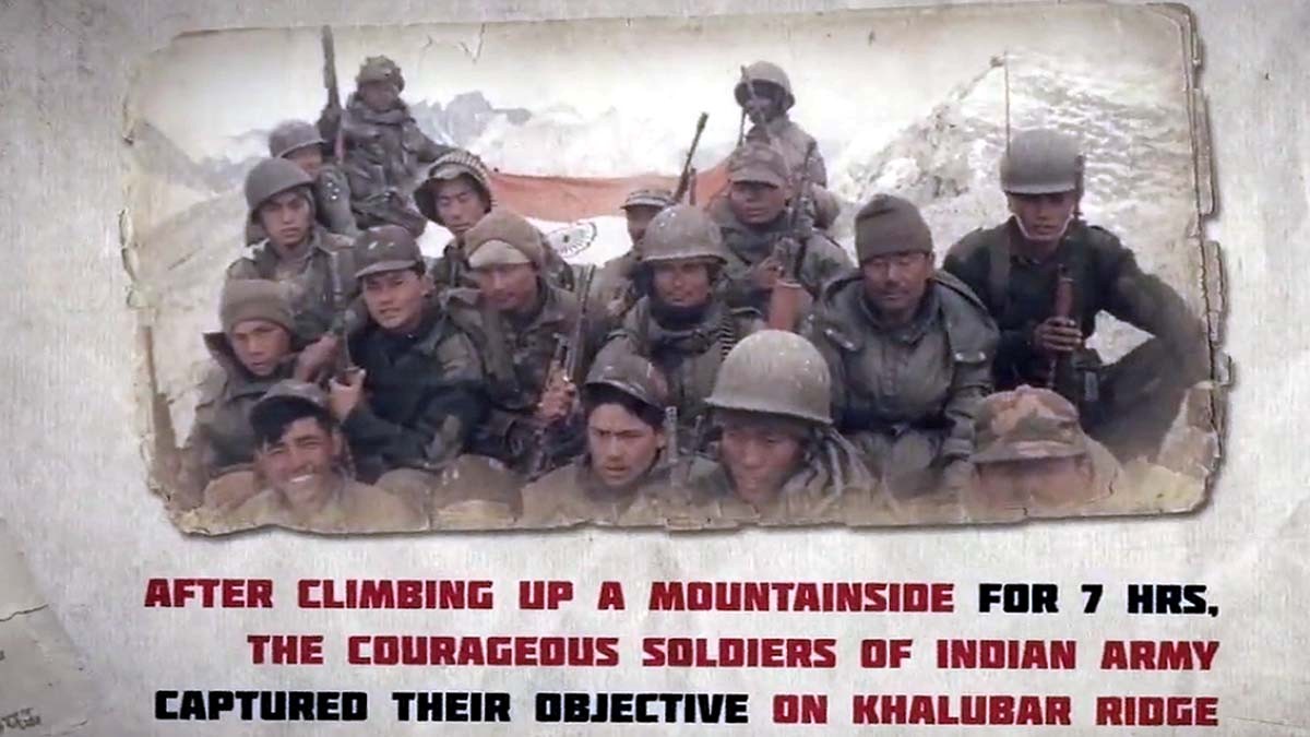
Batalik Sector: Key features in this sector included Khalubar and Chorbat La, which are essential for India to interdict enemy supply routes and administrative bases.

The Outcome of the Conflict
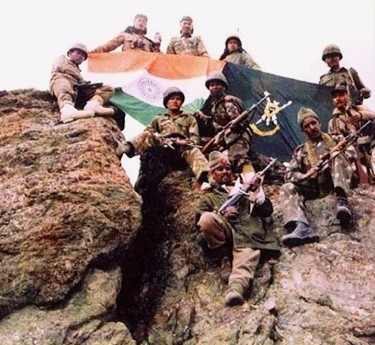
 The Kargil Conflict ultimately reaffirmed India’s military capability and resolve. The Indian Army successfully reclaimed the heights and positions occupied by Pakistani forces, emphasizing the importance of strategic planning, rapid mobilization, and effective coordination among ground troops, artillery, and air support. While the Indian victory was celebrated as a restoration of national pride, the tragic loss of lives necessitated a period of introspection. The Indian Army had successfully defended the nation’s territorial integrity, and Indian diplomacy effectively garnered international support; however, the conflict exposed significant shortcomings in the intelligence and security management frameworks.
Kargil Review Committee
Recognizing the need for a comprehensive evaluation, the Government of India established the Kargil Review Committee (KRC) shortly after the conflict concluded. The KRC Report highlighted serious deficiencies in India’s security management, particularly in intelligence gathering and border defense protocols. This led to the formation of a Group of Ministers (GoM) tasked with analyzing the report and developing actionable recommendations.
Strategic Reforms
In response to the KRC findings, the GoM proposed several critical reforms aimed at enhancing national security:
- Integrated Defence Staff: The establishment of an Integrated Defence Staff aimed to streamline military operations and ensure more effective coordination among the armed forces.
- Intelligence Integration: Efforts were initiated to unify the various intelligence agencies to improve information sharing and operational effectiveness.
- National Security Advisor: The appointment of a full-time National Security Advisor was established to provide continuous strategic oversight and guidance.
- Chief of Defence Staff (CDS): CDS was appointed, intended to serve as a single point of military advice to the government, thereby enhancing jointness and addressing inter-service doctrinal, planning, policy, and operational challenges.
Enhanced Military Deployment
To address the vulnerabilities that allowed for undetected intrusions, strategic adjustments were implemented. A dedicated mountain division was deployed in areas that had previously only hosted a brigade, significantly bolstering the region’s defense capabilities. Additionally, a new Corps Headquarters was established in Ladakh to enhance command and control, ensuring a more robust response mechanism for future threats. Through these measures, India aimed not only to rectify the deficiencies exposed by the Kargil Conflict but also to create a more resilient defense posture capable of addressing the complexities of contemporary security challenges.
Alternate Route Connecting Ladakh
National Highway 1 (NH 1) serves as a critical lifeline connecting the Union Territories of Jammu & Kashmir and Ladakh, running through key locations such as Uri, Baramulla, Srinagar, Sonamarg, Zoji La, Dras, Kargil, and Leh. While NH 1 is essential for both military and civilian logistics, the Leh-Manali Highway via Atal Tunnel provides a strategic alternative route. This secondary highway not only offers additional access points to Ladakh but also enhances operational flexibility for military movements, supply chain resilience, and emergency evacuations, ensuring that the region remains accessible under varying conditions.
The strategic role of Kargil in India’s defense and geopolitics cannot be overstated. The historical significance, underscored by the Kargil Conflict, continues to influence contemporary military strategies and regional stability. As India navigates the complexities of its relationships with neighboring countries, the importance of Kargil as critical bastions of defense remains paramount.